
Thursday, April 23, 2015
It's been awhile since I've posted anything and it's time to let you know why. I will be ceasing this blog as Heinz and I have decided to settle down a bit and take some time off from traveling. If things change I'll be sure to start posting again. It's been fun. Enjoy your life and be sure to take some time for seeing the world.
Thursday, November 6, 2014
Fall Travels With Pops
Bidding a fond
farewell to Alaska, Heinz and I traveled south through mile after mile of
incredible yellow color…yellow trees, yellow shrubs, yellow grasses,
interspersed with touches of red, orange, green, and blue. From Anchorage to Montana it was absolutely
amazing. (I would like to extend
thanks to Heinz and Pops for contributing photos to this blog entry.)


Traveling from
Alaska to Colorado you just about have to pass through Watson Lake and Dawson Creek. And if you’re passing through, there
are two stops you absolutely have to
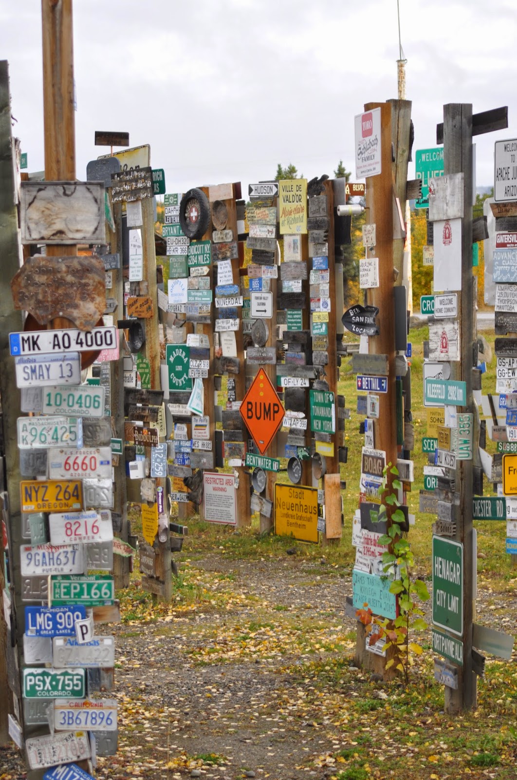
make. Stop number one is the Sign
Post Forest in Watson Lake.
The Sign Post Forest began during the Alaska
Highway Project in 1942 when U.S. soldier Carl K. Lindley spent time in Watson
Lake recovering from an injury. A commanding officer asked him to repair and
erect the directional signposts for the local Army Airfield, and while
completing the job he added a sign that indicated the direction and mileage to
his hometown of Danville, Illinois. Others added their hometowns and the trend
caught on. Over the years more and more travelers stopped to add a sign. In 1990, a couple from Ohio added the
10,000th sign in the Signpost Forest. Today, there are over 77,000 signs in the
Forest, and the number grows each year as visitors from all over the world contribute
signs and continue the tradition. The Town of Watson Lake maintains the site,
adding more posts as they fill up.


The second stop
is in Dawson Creek and is the Mile 0 marker for the Alaska Highway. Driving distance from Dawson Creek to Fairbanks is 1,488 miles.

Heinz and I took
6 ½ days to make the 3,000+ mile drive from Anchorage, AK to Grand Junction, CO…whew. We were just a tiny bit tired when we
got there. Four days after
arriving we packed my dad into the rig and headed out again. This year he decided to spend the month
of October traveling with us. Last
spring he mentioned that he’d been to every state in the U.S. except five. Since four of them were in the
northwest that’s the direction we headed to show him Idaho, Oregon, Washington,
and Montana, leaving Rhode Island as the last state he has left to visit. Hmm, maybe next fall.
Our first stop
was Salt Lake City, Utah. Pops had
been there years ago - as in passing through on a train while on military leave
in 1943. Heinz and I decided that
it probably didn’t count and we lined up a few of the sights to see.
The Salt Lake
City Temple is literally the original center of the city. According to church history, within days of the July 1847 arrival of the first company of Latter-Day Saint pioneers, Brigham Young waved his hand over a spot of hard, dry ground, and announced that at that precise location they would build their temple.
Church leaders designated a 10-acre plot of ground as Temple Square, instructing surveyors to lay out the city on a grid pattern that would be square with the compass and with the temple in the middle. Original pioneers named streets according to their distance and direction from Temple Square - 600 South is six blocks south of Temple Square; 300 West is three blocks to the west, and so on.
In building the temple, workers painstakingly chiseled out huge granite blocks that weighed from 2,500 to 5,600 pounds each from Little Cottonwood Canyon, approximately 20 miles from the temple site. The blocks were then carefully transported to Temple Square, first by ox-drawn wagon and later by railroad. There, expert stonecutters carved the blocks to fit perfectly into place.
Most of the work was done by donated labor as pioneer men and women took time off from the backbreaking work of establishing their "Zion" to contribute their time, skills and materials to the temple project. The temple was completed in 1893, more than 40 years after construction officially began. Brigham Young did not live to see its completion.
With Salt Lake City being in the heart of Mormon country, our visit had to start at Temple Square and the building downtown. The square is still owned and maintained by the Mormon Church. It has the Temple, two Visitor Centers each featuring displays on Mormon history, the Church Tabernacle, the Family Research Library for genealogy, museums, historical homes, and several other Church buildings. The only building that tourists may not tour is the Temple itself as only "Temple recommended" members of the Latter Day Saints are allowed inside.

Salt Lake City Temple of The Church of Jesus Christ of Latter-day Saints.
Legend has it that Brigham Young originated the unusual design of the now-famous Tabernacle on Temple Square after contemplating a hollowed-out eggshell cracked lengthwise. Young wanted the Tabernacle roof to be self-supporting, without pillars or posts to obstruct audience views, so bridge-building techniques of the day were employed. Built with 60-foot tall arched timber trusses made of lattice timbers that span 150 feet, using steam to bend the massive beams and then adding weights at both ends. Construction of the Tabernacle lasted 12 years, from 1863 to 1875. The American Society of Civil Engineers now recognizes the building as an engineering milestone. It was added to the National Register of Historic Places in 1970.
The red sandstone for the Tabernacle's 46 supporting piers was quarried from Red Butte Canyon, east of Salt Lake City. Nearly 1.5 million feet of lumber was hauled from the Wasatch Mountains to complete the project.


The organ of the Tabernacle has 11,263 pipes made of wood, zinc, and various alloys of tin and lead.
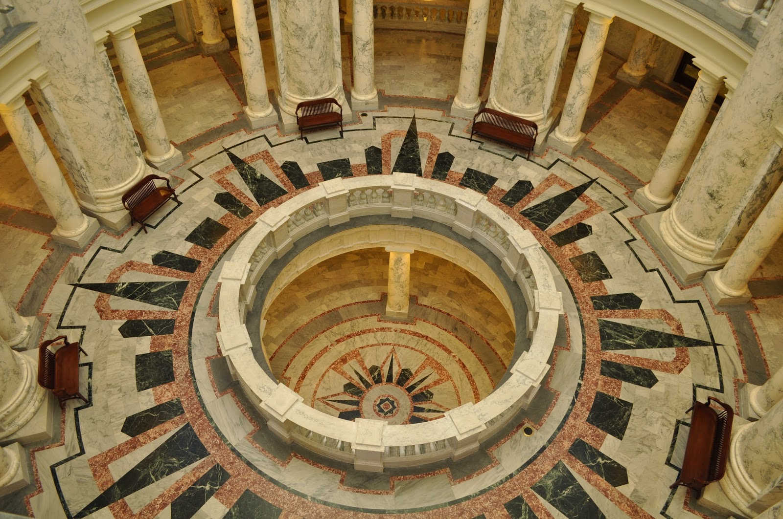
We also peeked into the Utah State
Capitol building and joined in on a tour. The
building was constructed between 1912 and 1916, using granite from nearby
Little Cottonwood Canyon. The dome is covered with Utah copper. There are 52
Corinthian columns. Throughout the grounds, on the building itself, and within
the interior are countless beehive representations. The beehive is Utah's state
symbol, representing the values of industry and cooperation.
Inside, the Capitol is divided into
two wings, each lined by marble Ionic columns weighing 25,000 pounds, with the
Supreme Court on the east end and the House of Representatives on the west. In the center is the 165-foot tall
rotunda. The ceiling of the rotunda is beautifully painted with clouds and
seagulls, paying tribute to the state bird. Twelve paintings lining the rotunda
were a WPA project, painted elsewhere and then attached to the walls. The
paintings depict scenes from the early history of the state.

Utah State Capitol building.

Beehive depiction on a door
handle.

Painting on the rotunda wall depicting
pioneers traveling to Utah.
Next, we took Pops over to the Tracy Aviary – a spot that Heinz and I
enjoyed on our last trip to the city.
In 1938, a visionary named Calvin R. Wilson became the manager of the
new aviary that would be located in Liberty Park and populated with birds
donated by a local banker by the name of Russell Lord Tracy. A park within a park, the Tracy Aviary
is now located on 8 acres inside Salt Lake City's Liberty Park. Boasting about 400 birds, the aviary has narrow paths winding among tall trees and
clusters of bird homes (homes? You know what I mean), which are interspersed
with ponds and picnic areas.


Red-crested Cardinal (South America)

Supervising the cleanup…

And then I ran across these strange
specimens that were identified as a mysterious migratory species.
Of course you
can’t visit Salt Lake City without experiencing the Great Salt Lake and
Antelope Island. The lake is the
remnant of the prehistoric Lake Bonneville that covered more than 20,000 acres
during the Ice Age. The current
lake size is 75 miles long and 28 miles wide. Water flows into the Great Salt Lake via four rivers. The only outlet is evaporation, which leaves
high concentrations of minerals.
The lake is generally five times saltier than the ocean. Only brine shrimp, brine flies, and
several types of algae survive in the waters, providing a food source for
millions of migrating birds.

Antelope Island
has more than 40 freshwater springs that support island wildlife and
vegetation. Bison are the island’s
most famous residents. Twelve
animals were introduced to the island in 1893 and were the foundation for the
500-700 bison living on the island today.
Other residents are the namesake pronghorn antelope, mule deer, and
California bighorn sheep.
Predators include coyotes, bobcats, badgers, and numerous birds of prey.


Leaving Salt
Lake City we decided to follow a squirrel and went to Promontory, Utah. You remember what happened there don’t
you? Come on - think back to your
history classes. This was the site
of the joining of the transcontinental railroad on May 10, 1869. On that day two locomotives - Central
Pacific’s Jupiter and Union Pacific’s
No. 119 - pulled up to a one-rail gap
left in the track. After a golden
spike was symbolically tapped, a final iron spike was driven to connect the
railroads. The Central Pacific had
laid 690 miles of track across the Sierra Nevada range and the Mojave
Desert. The Union Pacific had laid
1,086 miles across the open plains.
The golden spike is now housed in the museum at Stanford University in
California.

Reproduction of Central Pacific’s Jupiter.

Reproduction of Union Pacific’s No. 119.

Location of the last tie connecting the tracks.
Then it was on
to Lava Hot Springs, Idaho. Yes,
that’s the name of the town. We
stopped there for the night so Pops could have his first encounter with natural
hot springs. He loved it and informed us that if we
could find another one along our route he wouldn’t be upset if we stopped. Unfortunately our route never took us quite near enough to hop into another one.

Boise, Idaho
looked interesting so we dropped in for a bit. While there we took a tour of the State Capitol Building and
Pops decided he wanted to see all the state capital buildings along our
route.
In 1905, the
Idaho legislature passed the bill authorizing construction of a new and
improved Capitol Building. A local
firm of architects was hired and began construction that same year. The central parts of the Capitol,
including the dome, were built first, and completed in 1912. From 1919 to 1920 the wings holding the
House and Senate chambers were constructed. Most of the structure is made of sandstone taken from Table
Rock near Boise. Convicts from the
old Idaho Penitentiary were responsible for transporting the 10-ton sandstone
blocks from the quarry to the construction site. Almost all of the interior of the building
is marble, red from Georgia, gray from Alaska, green from Vermont and black
from Italy.
Idaho’s Capitol
Building is the only one in the United States heated by geothermal water. The hot water is tapped and pumped from
a source 3,000 feet underground.
.jpg)

Columns of Alaskan marble.
Rotunda floor with all four marbles.

Rotunda ceiling.
Speaking of convicts
from the old Idaho State Penitentiary - we drove over to check it out. This prison opened in 1872 and closed 101 years later. The site was selected because of its
proximity to the growing agricultural center in Boise and to the sandstone
available nearby. Inmate laborers
built the buildings on site. The
penitentiary grew from a single cell house into a complex of several buildings
holding Idaho’s most notorious criminals.
Ironically it shares space on the National Register of Historic Places
with the Tabernacle.
Over the years
the prison housed 13,000 inmates with a maximum of 603 at any given time. The youngest inmates were a 10 y/o who
served one year for killing a man, and an 11 y/o serving nine years for
shooting his mother. The oldest
inmate was an 81 y/o who served three years for cattle rustling. The prison also housed 222 women over
the years.


Cell house reflected in
the windows of another cell house.
From Boise we
traveled west to Oregon, another state crossed off the list for Pops. We headed to the southern end of the state
to show him Crater Lake. The lake
is famous for its deep blue color and water clarity. It partly fills a nearly 2,148 foot deep caldera that was
formed around 7,700 years ago by the collapse of the volcano Mount Mazama. There are no rivers flowing into or out
of the lake. Evaporation is
compensated for by rain and snowfall at a rate such that the total amount of
water is replaced every 250 years.


Pops and me at Crater Lake.

We soon turned
the rig northward and set our sights on Salem & Portland, Oregon. Salem is the state capitol so we HAD to
stop and see capitol building number three. Unfortunately it was a Saturday and the building was closed
– so we toured the exterior and grounds.
The building was constructed from 1936-1938 and is the third to house
the Oregon state government. Two
former buildings were destroyed by fire, one in 1855 and the other in
1935. New York architects
Trowbridge and Livingston designed the marble building in an Art Deco
style. The Public Works
Administration partially financed the construction in order to keep
construction crews employed during the Great Depression.
Throughout the grounds are native trees and shrubs, including blue spruce, Oregon-grape, giant Sequoia, coastal Redwood, Japanese maple, several Dogwood species, Bradford pear, Cherry tree species, English holly, rhododendron and magnolia tree species. One Douglas fir tree was grown using a seed that rode aboard Apollo 14 to the Moon in 1971 and was transplanted to the capitol in 1976 from Oregon State University.
Throughout the grounds are native trees and shrubs, including blue spruce, Oregon-grape, giant Sequoia, coastal Redwood, Japanese maple, several Dogwood species, Bradford pear, Cherry tree species, English holly, rhododendron and magnolia tree species. One Douglas fir tree was grown using a seed that rode aboard Apollo 14 to the Moon in 1971 and was transplanted to the capitol in 1976 from Oregon State University.


The figure atop
the dome represents the “Oregon Pioneer”.
It is an 8½-ton, 22-ft. high bronze statue with gold leaf finish.

Pops standing next to two partial
columns from the second capitol building that have been placed on the lawn of
the current building.

Heinz standing by a coastal redwood
growing on the building grounds.
We didn’t stay
long in Portland, but got a chance to show Pops some sights he said he’s heard
of all his life, but never thought he’d see. Our first stop wasn’t on his list, but we just had to take
him to Voodoo Doughnuts. You may
remember me raving about this place back in the spring. Well, the doughnuts are just as good in
the fall!

Next on the
agenda was a drive across the border into Washington to see Mt. St.
Helens. I’m sure everyone’s heard
of the May 1980 eruption that collapsed the north face of the mountain, sending
rock debris, ice, ash, and slurries of mud and rock hurtling down the
mountain. The volcano continued to
erupt until 1986, quietly building a lava dome. How many of you knew that the latest series of eruptions of
Mt. St. Helens occurred as recently as 2008? I didn’t until this trip.
In October 2004
the volcano began to erupt again with more than 1,000 small earthquakes per day
and steam and ash eruptions. A new
lava dome rose from the crater floor and grew continuously at a rate of more
than a dump truck load of lava per second. This extrusion of mostly gas-free, semi-solid lava continued
until February 2008. During the
3-year-long eruption, a total of 92 million cubic meters (36,000 Olympic
swimming pools) of lava was released onto the crater floor. Together the 1980-1986 and 2004-2008
lava domes have replaced about 7% of the volume lost in the May 1980 eruption.


Pops picking up a lava rock and
finding out it’s a tad heavier than it looks.
The next morning
we headed down to the Columbia River and its Gorge. Up to 4,000 feet deep, the canyon stretches for over 80
miles as the river winds westward through the Cascade Range, forming the
boundary between Washington and Oregon.
The gorge transitions from an area with 100 inches of annual precipitation,
to an area with only 10 inches of annual precipitation in its 80 miles of
travel. This creates a wide range
of ecosystems from the rain forest on the western end, to grasslands on the
eastern end. Along the way we
stopped in at the Columbia Gorge Interpretive Center Museum. The museum tells the story of the
geologic history and the people who have inhabited this region.


Sculpture of an Indian fishing in the
Columbia River.

Circa 1930 logging truck.

Pops standing by the logs on the
truck. Now that’s a log!
Leaving Oregon
we crossed over into Washington.
But that’s another story.
So I’ll leave you with some colorful shots from along the way.


And… Our friends
for the day are:


Subscribe to:
Posts (Atom)