The squirrel chasing continued to Page, Arizona – a
sleepy little place in the northeast of the state. Originally known as Camp Page, the town was cobbled together
on desert land acquired in trade with the Navajo Nation. It originally served as home to hundreds
of construction workers hired to build the country's second largest dam at Glen
Canyon on the Colorado River. Is this a town a bit off the beaten
path? Well, let’s just say that
the federal government has officially designated it as being the most remote
community in the country.
However, Page has several things that are
attractive to tourists. First, it is the exact center of what has been dubbed
the Grand Circle. The roads radiate out toward the Grand Canyon, Bryce
Canyon, Zion, Canyonlands, Grand Staircase Escalante, and Vermilion Cliffs.
Second, it is on Lake Powell, a jewel of a lake that was created by the
Glen Canyon dam, 186 miles long with 1,960 miles of shoreline. And third, it is the location of the
Antelope Slot Canyon – a bucket-list destination for most every photographer.
We spent four nights at the Page Lake Powell RV
Campground. While in town we took in some of the sights including a short hike
(only 1.5 miles) to Horseshoe Bend on the Colorado River. Horseshoe Bend is a
tremendous curve on the river. To get there you first trudge up a sandy
hill that lies on top of Navajo Sandstone, a uniform, smooth sandstone layer
that stretches from Arizona to Wyoming - over two thousand feet thick in
places. Then the trail takes you
over bare sandstone. When you
reach the edge of the bend, you look down 1,000 feet of sandstone cliff to the
river.

Horseshoe Bend in the Colorado River

Navajo Sandstone cliffs
Later we drove up to Grand Staircase Escalante to
watch the sunset from Alstrom Point. To quote the guidebook, "Fill
your tank with gas, pack a lunch, and bring along your camera, binoculars and
sunscreen for a transcendent experience as you travel along the backside of
Lake Powell. The trail leads you to the ultimate destination of majestic
views high above the lake where you can create picturesque memories of a
lifetime." It also mentions that a high-clearance or 4-wheel drive
vehicle is recommended. Hey, no problem for the Element, right? Wrong!
We made it down the first 5 miles (paved), the second 3 miles or so
(gravel), the next couple of miles (dirt) and finally gave up 10 miles or so
short of our goal when we reached a flooded wash deep in mud and decided the
prudent thing to do was make a U-turn and head back out. A choice many others made by the
evidence of the tires tracks on the side of the road.

Dirt portion of the road

Hmm...time to chicken out
So instead we drove up the highway enjoying the sights
through the countryside. The Grand Staircase Escalante became a national
monument in 1996. It spans nearly 1.9 million acres on the Colorado
Plateau. The topography is comprised of 3 sections: the sandstone cliffs
of the Grand Staircase, the high mesas and deep canyons of the Kaiparowits
Plateau, and the red rock wilderness of the canyons of Escalante.

Sandstone cliffs of the
Grand Staircase

Red rock mesas of Escalante
On our last day in Page we popped up early to make
the 0900 tour of the Glen Canyon Dam. Turns out we popped up a touch early...
Arizona doesn't recognize Daylight Savings Time whereas the Navajo Nation we’d
just left does. So instead of making the 0900 tour of the dam, we took
the 0800 tour instead. But it was worth it; the tour was quite
interesting. Among the facts we learned was that the main purposes of the
dam were to provide water storage for the southwest region and to generate power
for the area. Colorado River
reservoirs provide irrigation waters for an estimated 25% of the nation's food.
Concrete placement began in 1960 and continued 24 hours a day until the
final bucket was dumped three years later. A bucket held 24 tons of damp
concrete, and it took over 400,000 of them to build the dam, enough to build a
4-lane highway stretching from Phoenix to Chicago. The dam created Lake
Powell and only took 17 years to fill completely.
The plant generates power serving a five-state grid
of Wyoming, Colorado, Utah, New Mexico, and Arizona. The electricity
produced can provide enough energy to serve the needs of approximately 1.5
million users. It is estimated that the dam will be usable for 300-500
years.

Glen Canyon Dam

Dam turbines
After the tour of the dam we headed back into town
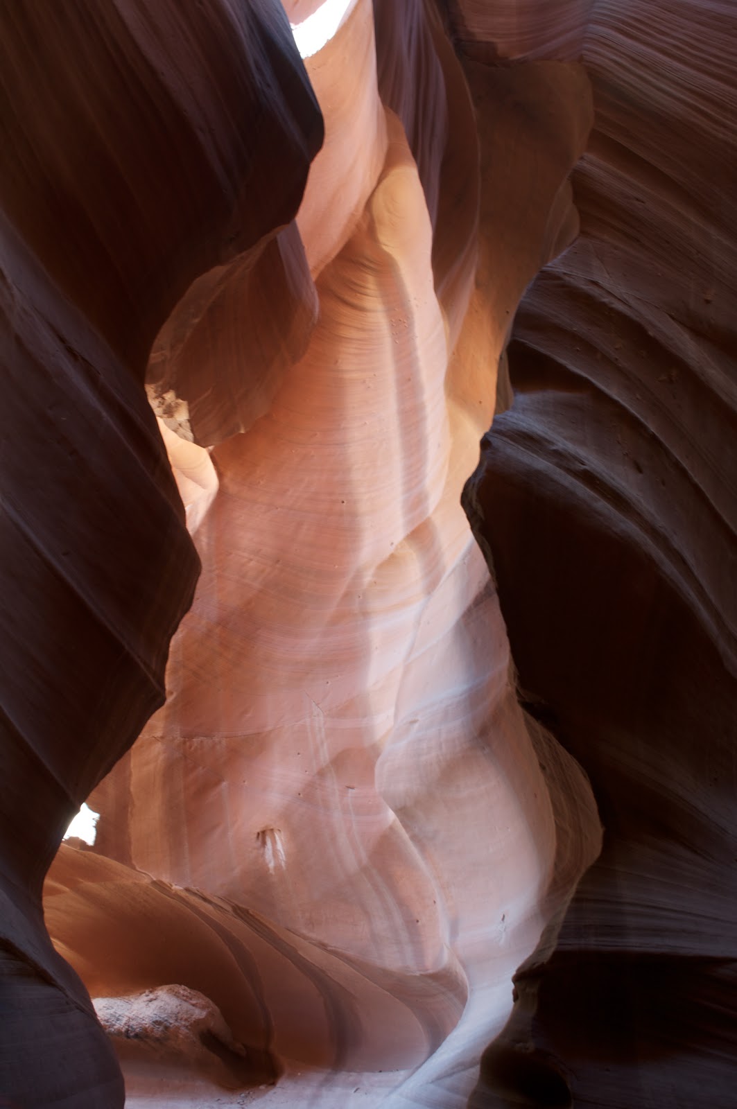
to the office of Chief Tsosie's Antelope Slot Canyon Tours. We took the
afternoon photographic tour of the upper slot canyon, the most photographed
canyon in Arizona. The colors and natural waves in the rock made by thousands
of years of flowing water and whirling winds are a photographer's dream-come-true.
The canyon is a narrow, twisting passageway approximately 1/4-mile long,
150 feet deep, and at times only a shoulder-width across. The canyon is
on Navajo land and you must have a licensed native guide to see it. If
you make it to Page, you must bring your camera and tripod and shoot the
canyon! Our guide was quite
knowledgeable about the best angles and spots for photography and even took
over the picture taking for one woman who couldn’t get the hang of her new
camera. Here are a few of the
sights we managed to capture.

Photographer: Heinz

Photographer: Teresa

Photographer: Heinz

Photographer: Heinz
Photographer: Teresa

Photographer: Teresa

Photographer: Heinz

Photographer: Teresa
Leaving out of Page, we headed for the Grand
Canyon. Unfortunately the direct route between Page and Flagstaff had been
closed due to a rockslide that destroyed part of the highway back in
February. So we headed southeast
back down to Highway 60, an extra couple of hours on our journey. In the middle of nowhere, 25 miles east
of Tuba City the engine suddenly quit. Heinz coasted over to the side of the
road and parked. He fiddled around with the engine without success for a
couple of hours, calling back and forth to the Cummins factory for advice.
Finally we called our handy dandy roadside assistance insurance company
and they set us up with a tow...from Flagstaff, a little over 100 miles west.
If you hit the road, get this insurance. Coach Net paid for the
tow--$225/hour x 4 hours = $900!! So, instead of spending two nights at
the Grand Canyon, we spent them in the parking lot of Rush Truck Services in
Flagstaff. Lots of dollars later we pulled out with a new-to-us rebuilt
fuel injection pump and headed south to the Phoenix area and McDowell Mountain
Regional Park.

Our baby headed to the truck hospital

Oh well, at least the sunset was pretty

Work in progress
This was the second time we’ve stayed at the McDowell Mountain Regional
Park. The campground has great
views of the mountain ranges surrounding the area, the Mazatal range to the
east, the Pinal range to the southeast, and the Superstition Mountains to the
south and is only 5 miles outside of the town of Fountain Hills. There are some incredible plants around
the area also and being spring, most were starting to bloom. Of course this meant that I was out photographing
plants and wildflowers, driving Heinz nuts.

The rig in place with the
Pinal Mountains in the distance

Sagauro cactus

Fiddleneck in bloom

Fiddlenecks backlit by the setting sun

Fairy Duster

Teddy Bear Cholla, the
little puff balls on the ground fall off the mother cactus and will grow new
chollas
Phoenix was fun although we only spent three days there. We took a day to ride around town, just
scoping out the place and visit the Heard Museum. The museum is known worldwide for its exhibits and programs
celebrating American Indian artists.
If you go expecting a museum of Indian history - this isn’t the
place. While there are some
historic exhibits, they are in place to give a context to the artworks. For example, on our visit there was an
exhibit called Home: Native People in the
Southwest. It showcased the
traditions of Native people of the past and present and examined definitions of
home. There was a Navajo Hogan
with a spectacular sand painting done in 2006 by a Navajo artist, a Pueblo
horno (outdoor bread oven), and over 400 kachina dolls donated by Barry
Goldwater.

Rug woven by Atsuma Blackhorse in the 1960’s. Blackhorse was born in 1886 and lived to be 108 years
old. In this rug, she recreated a
Plablita Velarde painting, “Sky Hunter and Prey” which shows a vulture swooping
in on a rabbit.
On our last day in the area we headed out on the
motorcycle to ride the Apache Trail. The
trail was originally a stagecoach route that ran through the Superstition
Mountains. It was named the Apache
Trail after the Apache Indians who originally used this trail to move through the area. The current Apache Trail links Apache
Junction at the edge of the Greater Phoenix area with Theodore
Roosevelt Lake, through the Superstition
Mountains and the Tonto
National Forest. Today, much of the Apache Trail is
paved, and the section east of Apache Junction is known officially as State
Route 88. The Trail winds steeply through 40 miles of rugged desert
mountains, past deep reservoir lakes like Canyon Lake and Apache
Lake. The narrow, winding road is
unpaved from just east of the community of Tortilla
Flat to Roosevelt Dam, a distance of 24 miles; there are steep cliff drops and little in
the way of safety barriers. The trail requires caution when driving and it is
not recommended for large RVs, SUVs, or caravans. Some large RV rental companies in the US do not
allow their vehicles to be taken on this route. Traffic dropped off drastically as we entered the unpaved
portion of the road, but the GSA made it through like it was made for it (hey,
I guess it was – eh?) - we were the only motorcycle on the road, even if we never did get above second gear.
The route was
absolutely superb! The
mountainsides were covered in yellow poppies, yellow desert marigolds, and
purple lupine along with all the bright green of spring growth on the
cacti. There were saguaro cacti
everywhere and when you consider that it takes 75 years to grow the first side
arm and they can live for over 150 years, we figured many of these were around
when the stagecoaches drove through.

The dirt portion of the road, check it out down in the valley.

Saguaro cacti along the route.

The hillside were full of amazing color.
Traveling home that
afternoon, we ran across the Tonto National Monument. So of course, we had to stop in and see what it was all
about (and get another stamp for the National Park Passport book). Turns out there are cliff dwellings there
– who’d have thunk it?
Archeologists have
found that the first people to settle permanently in the area arrived between
100 and 600 AD. Eagle Ridge, a
village of 15 pit houses is one of Tonto Basin’s earliest farming
communities. By 750 AD people from
the lower Gila and Salt River valleys arrived in the area and stayed for around
400 years, farming the desert via irrigation. Starting in the 1100s, the puebloans from Colorado began
moving into the area, building cliff dwellings. By the late 1300s climate changes caused the area to become
more arid, interspersed with catastrophic flooding of the Salt River that
destroyed valley farms and villages and undermined or destroyed the
centuries-old irrigation system.
By 1450 those struggling to maintain their way of life gave up and
migrated away from Tonto Basin.

Tonto cliff dwellings, one of hundreds of communities within the Tonto
National Monument.
Next stop was Tucson,
AZ. We’ve been to Tucson several
times now and have identified some favorite places there. We headed over to El Guero Canelo for a
Sonoran hot dog, to Beyond Bread for sandwiches and pretzels, and to the Blue
Willow for breakfast with my cousin.
We also tried a new spot, Teresa’s Mosaic Café (just seems appropriate
doesn’t it?) for Mexican. I think
it’ll land on the favorites list - mostly food from the Oaxaca region. If you’re in the Los Angeles area, the
family has opened a second restaurant in El Segundo.

Ahhh, Sonoran hot dogs at their best!

Stuff flies everywhere when the man eats – can’t hardly take him out
anywhere!

Breakfast with cousin Ruth at the Blue Willow.
We spent most of our
time in Tucson lazing around, doing some spring-cleaning, and minor maintenance
on the rig.
But we did take a
couple of hours out to tour the Air Force Materiel Commands’s 309th
Aerospace Maintenance and Regeneration Group (AMARG), better known as the
aircraft boneyard. This area of
Davis-Monthan AFB houses all excess military and government aircraft. There are currently around 3,500
aircraft stored here, down from a one-time high of over 6,000. Aircraft are brought here to be stored
indefinitely, pulped, stripped, or restored for service.

Sikorsky MH 53 helicopters

Nav T34C trainers

Miscellaneous planes and parts
Following Tucson we
drifted over to Yuma, AZ in the southwest corner. Neither of us had been to Yuma before and I doubt that we would
go out of our way to visit again.
We stayed at the Cocopah Indian casino. They have a 50 spot parking lot where you can dry-camp for
$5.00 for 3 nights - stay longer and you have to pay in casino points. We stayed two nights, so that was $2.50
a night – not bad! Then factor in
gambling losses and … well, never mind! Oh that man can whine, $20 at the penny slots is NOT a fortune lost!
I’ve heard of Yuma all
my life, probably due to the movie 3:10
to Yuma. Yuma actually got
started because it was the narrowest place along the Colorado River for fording
the river. While in town we
checked out the Quartermaster’s Depot from Fort Yuma and the Territorial
Prison. There’s not much left at
either location.
The Depot has three or
four restored buildings, furnished with period furniture. One interesting story was posted in the
dining room of the Quartermaster’s house.
His wife’s diary was quoted, “During dinner with guests we served water,
wine, and sweet milk, which we watched turn to curds on the table due to the
heat.” I can believe it; it was 96
degrees on April 4, with the summer heat yet to arrive.
After the
Quartermaster’s Depot we stopped in at a Mexican restaurant recommended by the
staff in the Depot gift shop, Tacos Mi Rancho. This was definitely the best part of Yuma! Heinz asked a gentleman at the next
table for recommendations and he enthusiastically said, “Get the special!” Carne Asada Ranchero, what a meal! This is good, down-home Mexican cooking
in the Sonoran style. Nothing
fancy, be prepared to wait, they cook everything as it’s ordered – and every
table is filled. The salsa was
obviously homemade, the chips fresh, the meat tender, the rice fluffy, I could
go on and on AND we got out for under $20.

Carne asada rancheros
The Territorial Prison
was our next stop. It opened on
July 1, 1876 when the first 7 inmates entered and were locked into the new
cells they had just built themselves.
It was in operation for 33 years until there was a need to expand but
the town of Yuma would not sell the government any land. It was then closed and the prison moved
closer to Phoenix. Only about 1/3
of the prison remains. The rest
was destroyed by townspeople seeking building materials and the Pacific
railroad that built a bridge and train switch station on land previously part
of the prison.
Apparently, while the
Yuma Territorial Prison had a harsh reputation among prisoners, it was known as
the country club on Prison Hill by the townspeople. All prisoners had to work at learning a trade. There was a library (the first in
Arizona) that the prisoners and townspeople alike were allowed to use, a school
where prisoners could learn reading; writing; arithmetic; music; and German,
Spanish, English as a second language; and a hospital that was the envy of the
area. There was a prison band that
gave community concerts. In
addition, in their free time prisoners were allowed to create arts and crafts
that were sold monthly in town.
Proceeds went to the prisoners so they would have some money when/if
they were released.
The prison also had
gravity-fed running water, forced air fans for air circulation and flush
toilets in the workshops and staff living quarters. There were even showers where prisoners were required to
bathe once a week.

Cell, 6 prisoners were housed in this space on three-high cots.
Originally the opening on the far side had been walled off.

Cell block, originally this portion had a second floor that housed the
prison hospital.
We’re in San Diego
now, so I’ll be posting again soon.
Here’s our
friends-of-the-day. We ran across
these little guys along the Apache Trail.