It was the
beginning of April, and we pushed north into Oregon. Neither of us had spent much time in Oregon before – so had few
preconceived notions about the area.
All we knew was that it was supposed to be really green, really gray,
really overcast, and really wet – like… all the time… like… ALL YEAR LONG. And, oh yeah, there are supposed to be
tons of outdoor activities to do here.
We wanted to find out for ourselves, as well as visit some of the cities
still on our list of potential places to settle into and call (our future) home. Yes, though not in a hurry, we ARE
still looking for places to call home when/should we park the RV.
Since we’ve
been here we’ve encountered bright blue skies, fog, dark grey clouds, rain, and
snow - about the only thing we haven’t encountered is a heat wave.
We stopped
first at Klamath Falls, and the Kingsley Field Air National Guard base. Their website listed an eight site,
full-hookup RV Park on base – how could we not take advantage of the service. Turns out that yes, there are eight
sites; and yes, there are full-hookups; but they forgot to mention that the
sites are located along the edge of the parking lot for the base gym. No matter, we settled in, hooked up,
and took off on a search for the nearest grocery store. Along the way we found the store in the
picture below. Now Klamath Falls
may be in the middle of nowhere, but they DO appear to be more open-minded that
we had initially given it credit for.

How thoughtful to cater to such a niche market.

But, tell me again how healthy your food is…
Klamath Falls
is a small town (around 20,000 residents) in southern Oregon located in the
middle of an agriculture area. In 1860, the Federal Government granted Oregon swamplands owned by the government. By 1867 Oregon opened these lands to settlers. That same year George Nurse secured 160 acres of marshy land and established Linkville on the Link River between Upper Klamath Lake and Lake Ewauna. Unfortunately, the Modoc Indians had been the first to settle in the area and resisted being pushed onto a reservation leading to a tribe rebellion. This led to the Modoc War of 1872, which ended up costing the U.S. Army an estimated $500,000 (over $8 billion in year 2000 dollars). The U.S. Army prevailed and by 1885, the town boasted 384 people, maintained by 7 stores, 3 hotels, 4 saloons, and was served by 4 doctors, four lawyers, and a newspaper. In 1893 the town was renamed Klamath Falls.
The town languished until 1909 when three railroad builders negotiated with local and state leaders for right of ways and land grants in the area. The Southern Pacific Railroad completed a line from Weed, CA to Klamath Falls that year and soon after 90 new businesses and public buildings were opened or under construction. By the 1920s Klamath Falls was a bustling town of sawmills, retain, and wholesale businesses. Since the bust in the logging business however the town has once again become a small rural town.
The area is
renown for outdoor activities such as hiking, hunting, and world-class trout
fishing. In addition, a complex of
six National Wildlife Refuges seasonally draw some of the largest
concentrations of water birds in North America, making the area a birdwatcher’s
paradise.
The town
itself did nothing to attract Heinz and I, so we wandered out to a few places
in the general area. First up was
an overnight trip over to Ashland, home of Southern Oregon University and the
Oregon Shakespearen Festival. Ashland is a small, but lively, town with historic buildings,
a marvelous park, paved intercity bike trails, and a busy restaurant scene.
Lithia Park was established in 1908 when the Women’s Civic Improvement Club
petitioned for the creation of a park along Ashland Creek. The town hired John McLaren, landscape
architect for San Francisco’s Golden Gate Park, to design it. The result is a 93-acre park along
Ashland Creek with undeveloped woodlands, a Japanese garden, two duck ponds, a
formal rose garden, volleyball courts, tennis courts, picnic areas, and more,
all located in the middle of downtown Ashland.
The Oregon
Shakespearen Festival traces its roots back to the Chautauqua movement of the
late 1800’s. The movement brought
cultural events and entertainment to rural communities across the nation. Ashland’s first Chautauqua building was
built in 1893. By the late 1920’s
the movement had died out and the building was finally torn down, leaving the
cement walls partially in place.
Angus Bowmer, an enthusiastic young English professor at Southern Oregon
Normal School (now Southern Oregon University) noted the resemblance between
the building site remains and some sketches he had seen of Elizabethan
theaters. He proposed producing a
“festival” of two plays within the walls.
The town council cautiously advanced him a sum “ not to exceed $400” for
the project. The Oregon
Shakespearean Festival was officially born on July 2, 1935 with a production of
Twelfth Night, followed the next
night by The Merchant of Venice. Reserved seats were $1, general
admission adults $0.50 and children $0.25. The Festival was a huge success covering their expenses and
making a profit.
The festival
continued to grow over the years and has become an award winning (including
several Tony awards) and internationally known regional theater company
attracting top-caliber professional actors. Currently the festival produces eleven plays on three stages
during a season that lasts from February to October. Traditionally, four of the eleven productions each year remain
Shakespeare plays. Heinz and I
stayed overnight in order to attend a performance of The Tempest. The play
was great. A modern interpretation
of the drama, it used a minimum of props, allowing concentration on the players
instead of the background.

Foggy skies heading into Ashland, OR.

Advertising Poster (courtesy Oregon Shakespearean Festival).
All over
southern Oregon we kept running across coffee kiosks called the Human
Bean. Heinz kept asking the staff what
a human bean was – and of course got crazy looks. I kept asserting that it was an agricultural project of the
Southern Oregon University Experimental Farm located by Kingsley Field. The resident scientists were combining
human and green bean DNA in an effort to produce beans that would pick
themselves. My version of events
was supported by the server handing over a large seed with each cup of coffee
ordered, obviously a ploy to get the general public to assist in the research
by planting them in home gardens.

The supplier of Human Beans.

Heinz contends that this is a candy coated coffee
bean…oh ye of little faith…don’t you recognize a Human Bean seed when you see
one!?

My theory was bolstered further by this dehydration
rack we ran across in Ashland.
Heinz insists it’s just really bad sculpture…HA, what does he know!
We took a break
from all that culture and drove up to Crater Lake National Park, just north of
Klamath Falls for a taste of the outdoors. Crater Lake was created approximately 7,700 years ago when a
massive volcanic eruption left a deep basin in the place where Mount Mazama’s
mountain peak once stood.
Centuries of rain and snow filled the basin, forming a deep blue lake
whose waters are some of the clearest and deepest blue of any in the
world. No streams flow into the
lake, so very little sediment clouds the pure water. Precipitation, balanced with evaporation and seepage, keeps
the lake water level consistent.

The road to Crater Lake.
Local native
tribes have oral traditions of members of their tribe witnessing the cataclysmic
eruption, details of which closely parallel known geologic details. After the
eruption, the area became a prominent ritual site for the tribes. Some years back, archeologists uncovered
75 sagebrush sandals from a cave nearby, buried under a layer of Mount Mazama’s
ash, lending credence to the tribal oral traditions.
It may now be
asleep, but Mount Mazama is not an extinct volcano. It may awaken with a new eruptive phase some day as the
geologic processes that built the Cascade Range continue just as Lassen Peak
and Mount St. Helens have done.

Crater Lake – 1,943 feet deep, 4.5- 6
miles across, 4.9 trillion gallons of water.
We spent some
time looking around the Visitor Center and the edge of the lake before meeting
up with the park rangers for a special treat…a snowshoe hike!

Summertime entrance to the Visitor
Center, there was an access path dug out on the end of the building for now.

One side of the access path.

Side of the park store and snack shop,
the windows are on the third floor.

This shot was taken along one of the
plowed roads, apparently this was a winter with very little snow…the average annual
snowfall is 43-45 feet!
The ranger-led
snowshoe walks are a great way to experience winter at Crater Lake. I’ve never hiked on snowshoes before;
heck, growing up in Louisiana I thought snow only belonged on postcards –
certainly nothing one hikes in!
But I was game to try, so Heinz and I rented some waterproof boots in
town and were ready to go. The
rangers supplied the snowshoes to a group of about thirty of us, showed us how
to strap them on, then divided us into two groups led by one ranger each. The walk lasted around 2½ hours across
some moderately strenuous terrain.
What a great experience…as I told the ranger, snowshoeing could make me
learn to like snow and winter.

Pre-hike doubts ALL OVER my face!

I thought this was snow ”shoeing”, not
“surfing”.
Are you sure the best way down
is headfirst?

You know, this is actually kind of
fun!

Heading across the meadow into the
woods.

Post-hike grin that I just could NOT
get off my face.

View of the lake at the end of the
trail.
Leaving
Klamath Falls we moved a few hours up the road to Eugene, OR, another city on
our list of possible retirement towns.
Eugene, at a population of 157,000, is the second largest city in the
state. It is another college town,
home of the University of Oregon Ducks (Really? With a mascot like that, is it any wonder they lost to
LSU!). We enjoyed the town, but it
didn’t make the cut for a future home.
Some of the nicest aspects of the area are easy access to outdoor
activities and good motorcycling roads, along with close proximity to the coastline. We did take some time to explore the
gardens in Hendricks Park. The
park, much like the one in Ashland, is in the middle of the town and has both
wild and cultivated areas, hiking trails, picnic areas, etc.

Heinz in front of a magnificent white rhododendron.

Rhododendron.

Japanese Magnolia.

Yellow Fawn Lily.
After Eugene
it was off to Portland. This city
has a reputation for rain, rain, and more rain. Yes, we did get some rain, but most days were a mix of sun,
clouds, and afternoon showers. Out
of curiosity I googled the rainiest cities in the contiguous U.S. Surprise, surprise… Portland doesn’t
even make the top 30. Mobile, Alabama
is number one at 67 inches annually followed by Pensacola, Florida at 65 inches
and New Orleans, Louisiana at 64 inches.
Contrary to what we thought, the Pacific Northwest didn’t even show up on
the list until Olympia, Washington at number 29. On the other hand, Seattle tops the list of cloudiest cities
with solid overcast an average of 226 days per year. Portland comes in second with 222 days.
Portland is a
dynamic city with something happening constantly. One day just after we got there, Heinz told me to dress in
nice jeans and shirt because he had an evening surprise for me. So I got dressed and we headed out to
poke around the city. First up was
a stop at Voodoo Doughnuts. Famous
around the world, this doughnut shop has over 90 different luscious bits of
dough on their menu.

The original Voodoo Doughnuts, there
are now 3 other locations in town.

Voodoo goodies, right to left:
Portland Cream (filled with Bavarian cream and topped with chocolate and two
eyeballs), Classic Cruller, Voodoo Doll (filled with raspberry cream, topped
with chocolate, and a pretzel stake through the heart), and an Old Fashioned
Cake doughnut.
That night I
got my surprise. Heinz had gotten
tickets to see Diana Krall, my absolute favorite jazz singer. I was ready to do flips…if I thought I
could actually do flips! I was in seventh heaven during the
entire concert. Once again I had
one of those grins that took hours to disappear.

Ready to tap my fingers, move my feet,
and be enthralled.
In no
particular order we did quite a bit in Portland. We spent some time in the original Powell Books in
downtown. This is the world’s
largest bookstore offering over four million new and used books. The store takes up an entire city block
and is three stories high. It’s
the only bookstore I’ve ever been in that gives out maps so patrons can find
their way around!

One city block...

4,000,000 books and counting, and one ecstatic book lover called Teresa!
We also
stopped in at the Architectural Heritage Center (AHC). This is a non-profit resource for
historic preservation. As “home
base” for heritage conservation in the Portland area, the AHC hosts programs,
tours and exhibits each year to build awareness of older and historic buildings
in the area. There was an exhibit of
antique house hardware on display the day of our visit. Heinz was completely enthralled.

Doorknob, late 1800s.

Door hinge, late 1800s.
If you need a
break from the hustle and bustle of the city the Lan Su Chinese Garden is a
quiet oasis in the middle of the busy city. It is only one city block in size but leaves the impression
of a much larger garden. Completed
in 2000, the garden is considered the most authentic Suzhou-style Chinese
garden outside of China. Most of
the building materials, including more than 500 tons of rock, came from China
and were assembled by artisans from Suzhou. Lan Su Garden is designed to engage all of your senses from
the rock mosaics underfoot to the sounds of rushing water, and seasonal
blossoms. There’s even a teahouse
with over 45 teas available for tasting.

Rock mosaic footpath.

Entrance to teahouse.

Teahouse from across the Fish
Pavilion.

“Reflections in Clear Ripples”, a
corner by the Fish Pavilion.

Who knew there were so many teas?

We finally decided on a “flight” of
three oolongs with almond cookies to munch.

View from inside the teahouse.
On a nice
sunny morning we drove down the Columbia River Gorge, heading east on the
Washington side of the river and returning on the Oregon side. The Columbia
River is the largest river in the Pacific Northwest, rising in the Canadian
Rockies and flowing south into Washington, then turning west to form most of
the border between Washington and Oregon before emptying into the Pacific
Ocean. In total the river drainage
basin is roughly the size of France and extends into seven U.S. states and one
Canadian province.
The river
supports several species of salmon, including sockeye, Coho, Chinook and
steelhead. Dams along the river interrupt
the migration of these fish, so some of the Columbia River dams employ fish
ladders. These are effective to
varying degrees at allowing these fish to travel upstream. At the Bonneville Dam Visitor Center,
underwater windows offer an eye-to-eye peek at the thousands of Chinook and
Coho salmon wriggling their way up the dam’s fish ladders each fall.

Bonneville Dam. Sorry, no pictures of fishing scurrying up the ladders – they’re still out at sea.
About halfway
down the gorge, we crossed over to the Oregon side at the Hood River
Bridge. This is a vertical lift bridge
in which the center span rises while remaining parallel to the remainder of the
bridge. It leads into a nice small town called appropriately, Hood River. We spent some time tooling around the
area and thought it quite a nice place, except...its main claim to fame is the amount
of wind that channels down the river gorge. These winds make Hood River the world’s best location for
wind surfing and the city annually hosts the world championships.

Hood River Bridge.

Hood River, OR.

Local artists creating a blown glass
vase.

Apple orchards outside Hood
River. The 35-mile Hood River
County Fruit Loop circles through the valley passing cherry, apple and pear
orchards, vineyards, berry farms, alpaca ranches, pumpkin patches, and lavender
farms.
We took a day
trip out to see Mount St. Helens.
This volcano erupted on May 18, 1980 killing 57 people and blowing down
or scorching miles of forest. Luckily
the eruption occurred on a Sunday when over 1,000 logging employees were enjoying
a day off or the death toll would have been much higher.
Shaken by an
earthquake measuring 5.1 on the Richter scale, the north face of this tall
symmetrical mountain collapsed in a massive avalanche of rock and ice. In moments the avalanche slammed into (and
obliterated) Spirit Lake, crossed a ridge 1,300 feet high, and roared 14 miles
down the Toutle River. A lateral
explosion ripped through the avalanche and developed into a stone-filled wind
that left over 150 square miles of forest blown down or left dead and standing.
Over 650 miles of logging and public roads, 16 miles of railroad, and 19
bridges were buried in ash or washed away by mudflows. A vast gray landscape lay where once
the forests grew.
In 1982 the
110,000-acre National Volcanic Monument was created. Inside the Monument the environment has been left to respond
naturally to the disturbance for research purposes. Outside the Monument, logging and lumber companies have
replanted the forests after harvesting the downed trees for processing. The recovery effort saved 850 million
board feet of timber - enough to build 85,000 three bedroom homes.

Mount St. Helens.

Trees blown down by the eruption in 1980.

National Monument schematic of the sequence of events around the avalanche.

Former location of Spirit Lake.

Panoramic photo of the valley.
After two
weeks in the Portland area, we headed west to Astoria OR. Astoria was the terminus of the Lewis
and Clark expedition and later Oregon’s first boomtown - a hub for fur traders
and fishermen.
One of the
town’s landmarks is the Astoria Column.
Built in 1926 on the highest point in Astoria, 600 feet above sea level,
it was styled after Trajan’s Column in Rome. It rises 125 feet from base to crown. Spiraling upward, a graphic timeline
depicts the history of the
Old West beginning with early explorers’ first contact with indigenous peoples and ending with the building of the railroad. Heinz tackled the 164 spiral steps to the top, but I opted for the ground view and stayed put.
Old West beginning with early explorers’ first contact with indigenous peoples and ending with the building of the railroad. Heinz tackled the 164 spiral steps to the top, but I opted for the ground view and stayed put.

Astoria Column.

Astoria-Megler Bridge over the mouth
of the Columbia River (from the top of the Astoria Column that I didn’t climb).
Of course
Heinz and I have to explore the surrounding countryside whenever we hit a town,
so off we went to Tillamook, OR - of milk, butter and cheese fame. The first settler in the vicinity was
Joseph Champion, who came in 1851 and made his home in a hollow spruce tree he
called his “castle”, if that gives you any idea of the size of some of the
trees in this part of the country!
By 1859 the tax roll for the county listed 48 taxpayers worth
$29,774.75, total taxes paid that year was $428.17. In 1885 the county tax rolls boasted “3,335 sheep, 30 goats,
2,207 hogs, 19 mules, 4,430 cattle, 500 legal voters, and 352 females over
18.” In 2011, the population of
Tillamook was 4,675 (and the county over 25,000), “with just about the same
number of cows”.
We passed on
the cheese factory tour and went straight to the Air Museum. The museum is housed in one of the few
remaining WWII blimp hangars in the nation. In 1942, with supplies of steel scarce, the U.S. Navy began
construction of 17 wooden hangers along the U.S. coastlines to house K-class
blimps to be used for anti-submarine coast patrol and convoy escort. Each hangar was 1,072 feet long, 192
feet high (over 15 stories), 296 feet wide, with over 7 acres under the
roof. Each hangar could house
eight blimps – they’re HUGE!
Today, these remaining hangars are the largest wooden clear-span
structures in the nation.

Hangar B, home of the Tillamook Air Museum.

Hangar doors, each door is 120 feet
high and weighs 30 tons.

Photo taken during construction in 1942.
Stationed at
Naval Air Station Tillamook was Squadron ZP-33 with a fleet of eight K-class
blimps. The K-ships were 252 feet
long and filled with 425,000 cu. ft. of helium. With a range of 2,000 miles and an ability to stay aloft for
three days, they were well suited for coastal patrol.

Airship sizes flying in 1942.

Location of naval blimp stations
during WWII.
The ones in black are existing hangars.
With the war
over, Naval Air Station Tillamook was decommissioned in 1948 and the hangers
ceded to the town. Over the years,
they were used for varied industrial purposes. In 1992, Hanger A was being used to store hay when a fire broke
out. Local firefighters could do
little but prevent the fire from engulfing Hanger B. Since 1994 the remaining hangar has been home to one of the
top five privately owned aircraft collections in the nation. All planes in the collection are
maintained and flown on a regular basis.

P-38 Lightning, note the oil drips
under the plane.

Japanese Ki-43 Hayabusa (Peregrine
Falcon) called “Oscar” by Allied reporting forces. It was often called the “Army Zero” by American pilots for
its side-view resemblance to the Mitsubishi A6M Zero flown by the Japanese
Navy.

War production poster.
On the side
of the hanger were some old train engines and cars that were rusting away on an
unused line of track. There was no
information about them but they made for some really interesting photo
opportunities.


We were
staying at the Camp Rilea Armed Forces Training Base in Warrenton, OR. As you pulled out of the base there was
a small church and cemetery at the side of the road. We stopped in to explore one day, and discovered that the
church was the oldest Presbyterian Church in Oregon, first meeting in
1859. The cemetery was the Clatsop
Plains Pioneer Cemetery, established in 1850 “as a common burying place for all
persons wishing to bury in the same, free of expense”. It is still used for that purpose
today.

Pioneer Presbyterian Church.

Family plot fence corner, Clatsop
Plains Pioneer Cemetery.


Clatsop Plains Pioneer Cemetery.
On a lighter
note, Camp Rilea sponsored a classic car show right next to our camping spot - so
of course we wandered over to drool a little.

1944 Studebaker Champion.

1939 Chevrolet.

Hood ornament – can’t remember for
what.
Along the way
we found the perfect sign for us as we moseyed our way into Washington.

Now here’s our friends of the day…

Hey, what ‘cha staring at
Buster?!
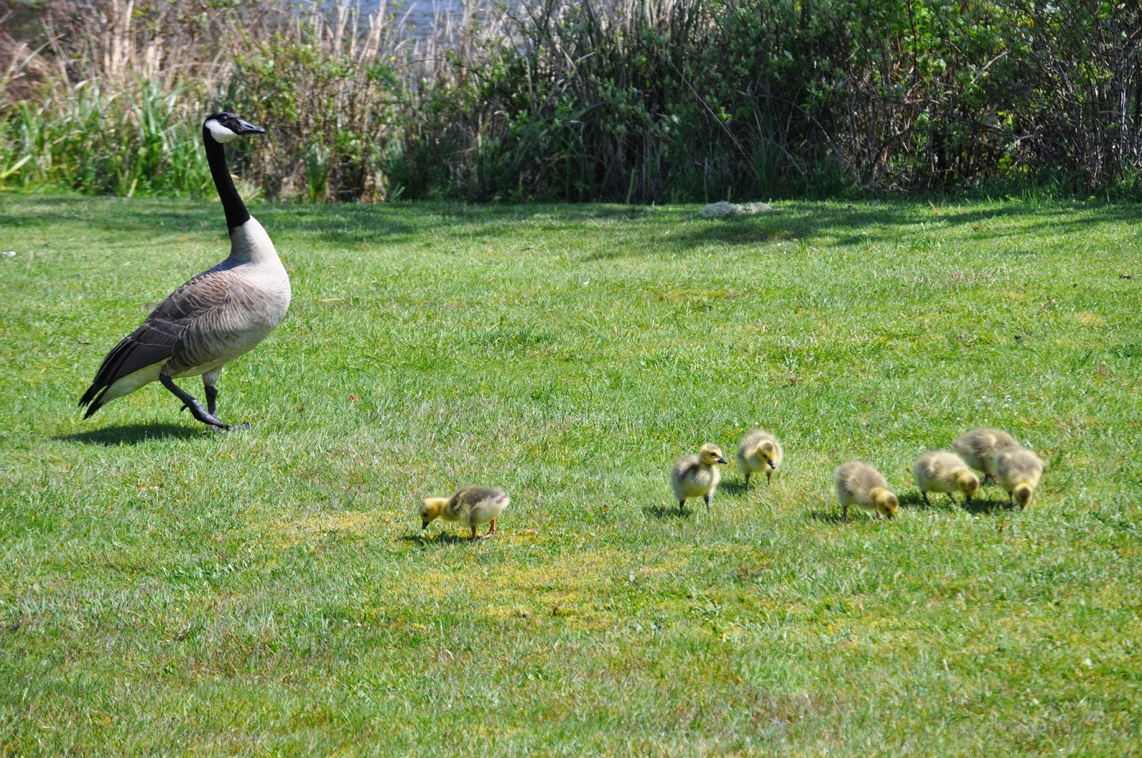
Stay together kids. Johnny, that means you too!

Ok class, today’s lesson is foot
paddling.
We’ll start off in the shallow end until everyone’s comfortable.
No comments:
Post a Comment